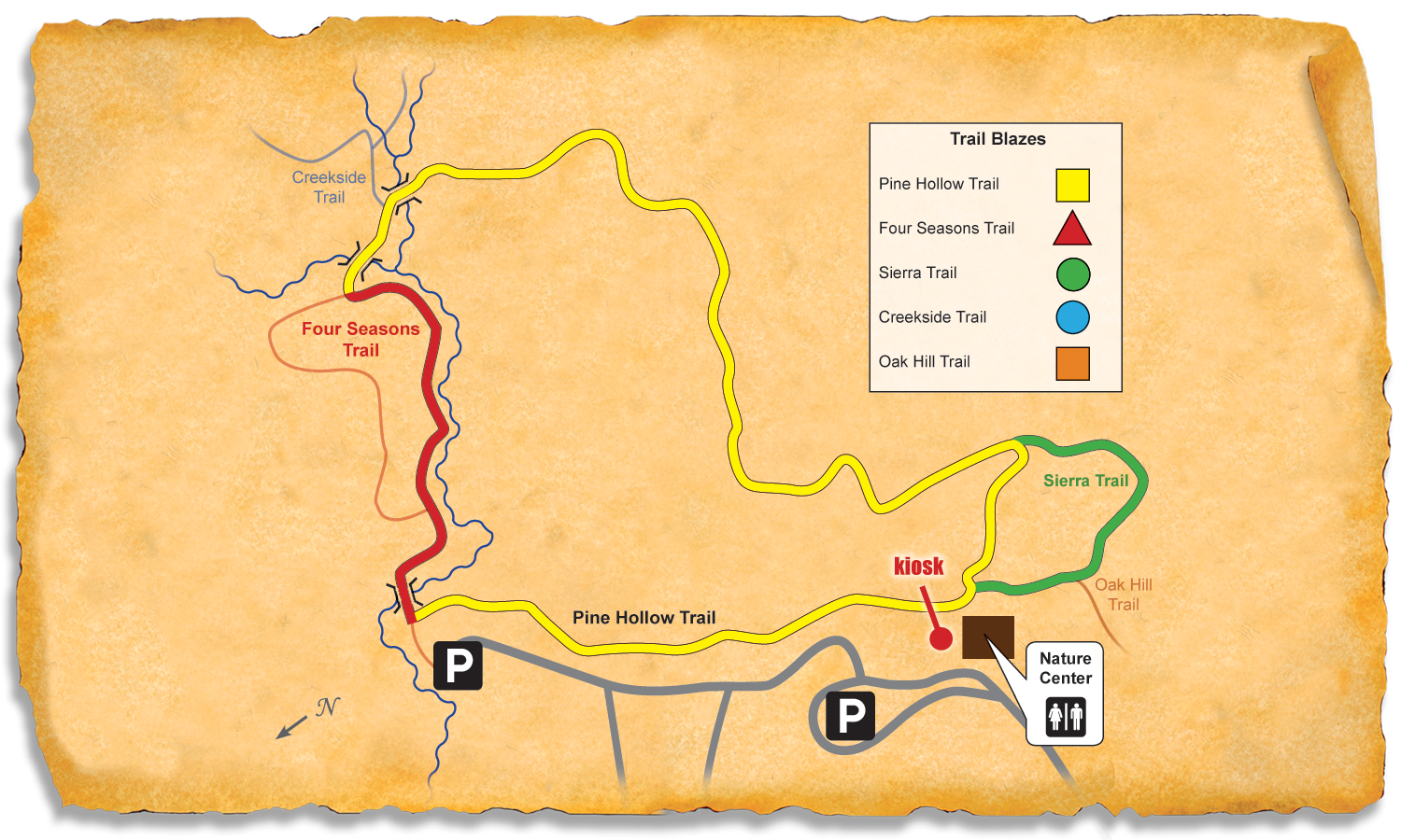
Three trails at McDowell
Walk from a wooded ridge into a creek hollow at Mecklenburg County’s oldest nature preserve. This circuit links three of the trails used by the local Kids in Parks program. The nature center exhibits native animals.
Walking and running times assume 18–24 and 9–12 minutes per mile respectively, before stops.
Find the start
Enter the preserve at 15222 York Road, Charlotte. Follow signs to McDowell Nature Center, then the trail kiosk. Start where the short Nature Center connector meets Pine Hollow. The center and the preserve keep separate hours.
Start coordinates 35.10004, -81.02023. The GPX contains the whole outing and its numbered waypoints.
Follow the route
Surface · Natural, Asphalt. Finish · Nature Center connector meets Pine Hollow Trail.
- Lap 0.00 mi · 672 ft
Nature Center connector meets Pine Hollow Trail
At the Nature Center connector, take yellow Pine Hollow northeast toward Four Seasons. Leave the close-by Sierra entrance for the end of the outing.
Locate point 1 on the map - Lap 0.25 mi · 575 ft
Change to Four Seasons
Join red Four Seasons toward the southern Pine Hollow connection. Where the paved trail divides, take its western, right-hand arc.
Locate point 2 on the map - Lap 0.41 mi · 592 ft
Return to Pine Hollow
At the next yellow Pine Hollow junction, leave Four Seasons. Follow the longer natural-surface Pine Hollow leg back west.
Locate point 3 on the map - Lap 0.94 mi · 633 ft
Take Sierra outside arc
At green Sierra, take its outside arc. Pass the Oak Hill branch and continue on Sierra toward its next meeting with Pine Hollow.
Locate point 4 on the map - Lap 1.08 mi · 667 ft
Return to short Pine Hollow leg
Rejoin yellow Pine Hollow near the nature center. Follow the short yellow section to the Nature Center connector.
Locate point 5 on the map - Lap 1.11 mi · 672 ft
Pine Hollow at the Nature Center connector
Finish at the same connector junction where the circuit began. Take the short approach back toward the kiosk and Nature Center.
Locate point 6 on the map
Elevation profile
The sampled terrain ranges from 575 to 690 feet above sea level along the course.
On foot
Walking. Four Seasons is the paved interval between two natural-surface legs. Read the trail names at each change: Pine Hollow, Four Seasons, Pine Hollow, Sierra, then Pine Hollow again.
Running. The longer yellow section returns over uneven natural ground. Ease back before the green Sierra turn and again before its short final junction with Pine Hollow.
Measurement and sources
Computed from the traced public trail centerline for one complete circuit. Distance on a watch can vary. The listed terrain elevations span 575–672 ft at the numbered points. They measure bare ground and can differ from the trail deck on bridges.
Route research and elevation checks dated November 3, 2026. Directions await on-foot verification. Follow signs and posted closures.
- Mecklenburg County Park and Recreation · McDowell Nature Center and Preserve
- Kids in Parks · McDowell Nature Preserve TRACK Trail
- Kids in Parks · McDowell TRACK Trail diagram
- Mecklenburg County GIS · Nature Preserve Trails
- Mecklenburg County Park and Recreation · Greenway closures and detours
- USGS · 3D Elevation Program · Waypoint readings · Profile readings