
Brooklyn
Between 1960 and 1967, Brooklyn was razed in five stages. 1,480 homes were demolished and 1,007 families displaced, mostly pushed to the northern and western edges of the city. Not a single new residential unit was built to replace them.
Those figures come from a research guide written by UNC Charlotte Public History graduate students working from archival sources, including the Kelly Alexander NAACP papers, in the university's Atkins Library.
What was there
It began as Logtown — the name appears on an 1892 Charlotte Townships map — on ground that lay lower than the city's other four wards, which made sewage and sanitation a persistent hazard. After emancipation, formerly enslaved people settled there. By 1917, when the first racially patterned map of Charlotte was drawn, the area was, in that map's description, "solidly black except for Trade, Tryon, College, and parts of Fourth Street."
What grew there was not a slum, whatever the redevelopment paperwork later called it. The research describes Brooklyn at its height as "an African American city-within-the-city, complete with its own downtown" — with everything from shanty housing to the homes of Charlotte's Black professionals.
It held a remarkable concentration of firsts:
- Myers Street School, built 1886 — Charlotte's first Black public school and the first Black grade school in the county. Families moved to Brooklyn so their children could attend.
- Second Ward High School, opened 1923 as Charlotte Colored High School — for nearly half a century the only high school in the city open to Black students. It closed in 1969, in the wake of integration, as Black schools were shut across the South and their pupils bussed to white schools.
- The Brevard Street Library — the first free library for Black patrons in the state of North Carolina. It opened two years after the Carnegie Library refused to admit Black readers.
- The A.M.E. Zion Publishing House, which printed all materials for the denomination in America and published its monthly newspaper. The research notes it was one of the very few Black-owned businesses where Black men could be trained and employed in a white-collar profession.
- A Black YMCA, the Queen City Drug Store, and dozens of churches and businesses.
J. T. Williams, a business, medical and political leader, built an elegant house on Brevard Street; he was appointed U.S. Consul to Sierra Leone under President McKinley and served from 1898 to 1907.
How it was taken
The historian Tom Hanchett's argument, as the research guide summarises it, is that Brooklyn became a community precisely because political disenfranchisement after 1900 pushed Black Charlotteans to build their own economy — and rising rents in white neighbourhoods pushed Black businesses in.
Then the ground shifted under it:
- Independence Boulevard cut what the research calls a "long gash" through the neighbourhood.
- In 1947, the city's new zoning plan relabelled all of Brooklyn "industrial."
- In 1958, the Charlotte-Mecklenburg Planning Commission commissioned a study of "blighted areas" in order to qualify for federal demolition money.
- The federal government granted the city $1,432,000 to clear thirty-three acres and relocate "about 250 families and many small businesses." The land was designated for light industry, offices and public buildings — a government centre around City Hall.
Residents said at the time that it would go badly. In 1958 Kelly Alexander of the NAACP wrote to the Redevelopment Commission pointing out that ninety-nine per cent of the affected residents were Black, and that:
"There is no public housing under consideration and the poor Negro families in the area are the victims of landlords and real estate men who are concerned only with making a profit."
No low-rent public housing had been built in Charlotte since 1953. The NAACP also wrote to the federal Housing and Home Finance Agency to say that Black residents had not been asked to take part in the relocation plans at all.
They were right. The clearance went ahead; the replacement housing never came; and Black businesses that depended on Black neighbours closed.
What survives
Very little — which is why what does survive matters.
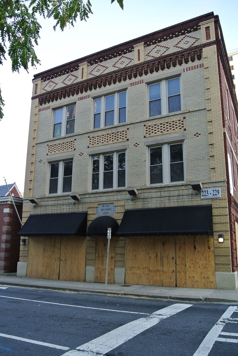
The Mecklenburg Investment Company Building, on South Brevard Street, was financed by Black professionals in 1921–22 to provide the first office building in Charlotte open to Black professionals, with a third-floor lodge hall used as a meeting place for Black civic groups. Its architect and builder, William W. Smith, designed its distinctive yellow and red patterned brickwork. It is on the National Register — listed in 1982 — and the Park Service records its areas of significance as Black history, architecture and social history.
The Second Ward High School Gymnasium, built in 1948 at 710 East Martin Luther King Jr. Boulevard, is a designated historic landmark. It is also, still, a working county recreation centre: Second Ward Gym. The school is gone; the gym where its pupils played is open to the public.
Why this page exists
Charlotte markets itself as a city that builds. This is what that has sometimes meant.
The pattern was not unique to Brooklyn. The digital mapping project for Charlotte's Historic West End puts it plainly: many of the city's historic Black communities "have been erased forcibly from the landscape by urban renewal policies in the 1970's and the city's economic expansion during the 1980's and 1990's." The West End survived largely intact. Brooklyn did not.
Going further
UNC Charlotte's Atkins Library holds the fullest public account, with archival collections and oral history interviews — recordings of people who lived there. Its research guide covers thirteen historically Black Charlotte neighbourhoods: Belmont, Biddleville, Brooklyn, Cherry, Derita, Enderly Park, Graham Heights, Greenville, Grier Heights, McCrorey Heights, Optimist Park, Shuffletown and Washington Heights. Special Collections is on the tenth floor.
Rose Leary Love wrote a memoir of growing up in Brooklyn, Plum Thickets and Field Daisies.
Places on this page, in detail
- Enderly Park · parks and open space
- Marshall Park · parks and open space
- Community · public art
- Industry · public art
- Mecklenburg Investment Company Building · Commercial
- Second Ward High School Gymnasium · Modern
- Mecklenburg Investment Company Building · Historic places
Read next
Local landmark or National Register? What the labels actually mean
If you have looked into an old Charlotte building you will have met both phrases, often on the same…
Who designed Charlotte: the planned suburbs
Drive through Dilworth, Myers Park or Elizabeth and the streets curve where a developer working to a…
Dilworth
Dilworth was laid out for Edward Dilworth Latta, and it kept his middle name. The National Register of…
NoDa (North Charlotte)
NoDa is short for North Davidson, the street it grew up along. The name is recent; the place is not. On…
The Historic West End
West of Uptown, around the campus of Johnson C. Smith University, is a network of neighbourhoods that…
University City
Charlotte's north-eastern quarter is organised around a university, a boulevard and a rail line, and…